


Filed under: maps, Uncategorized | Tags: buffalo creek, Chair Rock, fire, forest fire, Foxton Road, Lime Creek, lime gulch, MTB, Pine
via http://denver.cbslocal.com/2013/06/19/lime-gulch-fire-breaks-out-in-jefferson-county/
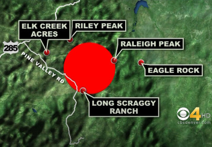
Buffalo Creek evacuated.
Filed under: maps, Uncategorized | Tags: arson, Black Forest, Colorado Springs, El Paso County, forest fire, Gabbert, wildfire
June 14. Not able to see streets very well. Via Bill Gabbert’s Wildfiretoday.com.
http://wildfiretoday.com/2013/06/12/black-forest-fire-colorado-springs/

click to enlarge
Filed under: maps | Tags: Cedar Heights, climate, Colorado Springs, Crystola, fire map, fire perimeter, forest fire, Garden of the Gods, Garden of the Gods Fire, Green Mountain Falls, Manitou, Manitou Springs, Mountain Shadows, science, Waldo Canyon Fire, Woodland Park
Today’s Events:
Fire activity is expected to increase today and tomorrow, with higher temperatures and decreasing humidity. Possible afternoon thunderstorms could also bring strong, gusty winds. Temperatures are expected to reach at least 15 degrees above season normal.
On the west side of the fire, crews will hold and improve line from Rampart Ridge Road south to Highway 24, eliminating hotspots where required, extinguishing roll-out logs, and continuing structure protection, with the aim of re-opening the highway as soon as possible. Night crews successfully performed a burnout operation in this area overnight.
Smoke may again be visible from Colorado Springs, as a large island of fuel within the fire perimeter continues to burn, but poses no threat.
Aircraft will make retardant drops on the northern perimeter as firefighters attempt to hold the fire south of Monument Creek. Three spot fires northeast of Rampart Reservoir are being aggressively attacked by air, bulldozers and hand crews. Firefighters will also continue construction of a contingency bulldozer line along Mt. Herman Road north of the fire.
Air resources will continue to be used to suppress fire activity in Williams Canyon on the southern flank of the fire.
via http://inciweb.org/incident/article/2929/14645/
Yesterday’s perimeter map:

click to enlarge
Filed under: maps | Tags: Anglestone, Blodgett Drive, Colorado Springs, fire fighting, forest fire, Garden of the Gods, Manitou Springs fire, Mount Saint Francis, Needlecone Lane, Rampart Reservoir, Sawback, Stanley Reservoir, USAFA, Waldo Canyon Fire, Woodland Park, Woodmen Road
I listened to the fire fight most of the day yesterday [Wednesday June 27, a day after 300-plus houses burned]. The fire made a bull rush on the houses above and west of Woodmen Road, around a street called Blodgett Drive and its associated cul-de-sacs, a little neighborhood placed to burn vigorously at the extreme northwest point of Colorado Springs.
The fire “flashed over” and many of the houses started to burn. Without quick action by multiple fire crews from all over the state, dexterously coordinated by radio and face-to-face meetings, the houses would have burned to their foundations.
After its big charge the fire kept up a cat-and-mouse game with the fire crews for the rest of the day, sneaking up on the houses through the brush. The situation was especially tense up on Angelstone, where five luxury homes sit in an exclusive little enclave hanging above the Blodgett Drive neighborhood. Fire smoldered on the hillside all day and into the night, and into the next day, as crews tended the houses with one easily blocked escape route.

The photo shows heavily wooded area behind Blodgett Drive and the houses perched on Angelstone. Woodmen Road is below.
At some point fire started in the open area west of Mount Saint Francis, below Woodmen Road. Fire fighters had already identified the nearby houses as a problem spot. The houses along Needlecone Lane and Sawback Trail were lined up along a gully that would “go up like a chimney” and so would be “very hard to defend,” according to radio traffic. But they jumped on it in the open area and put it out.

Screenshot shows the houses along Needlecone Lane and Sawback Trail below Woodmen Road. Mount Saint Francis is just off screen to the northeast.
If you live in this neighborhood, the fire fighters saved your house yesterday. Today is a different day.
Filed under: maps, Uncategorized | Tags: Cedar Heights, Colorado fire, Colorado Springs fire, fire map, fire perimeter, forest fire, IR map, Manitou Springs fire, Mountain Shadows, Rampart Reservoir, Waldo Canyon, Waldo Canyon Fire, wildland fire, Woodland Park
As of 0600 6/28 June.

Filed under: maps | Tags: Chipita Park, Colorado Springs, forest fire, Garden of the Gods, heat map, Hwy 24, Manitou Springs, Mountain Shadows, Rampart Range Road, The Mesa, Twitter, Waldo Canyon
Heat map about 12 hours old already…showing roughly 2500 acres burnt or burning.
via http://twitter.com/tommypez/status/216915772260352001/photo/1

click to enlarge
Filed under: maps | Tags: denver, forest fire, Fort Collins, High Park Fire, Larimer County, NOAA, smoke map, smoke plume, wildfire, wildland fire
High Park Fire filled Denver with smoke this morning, but the plume has since pulled back.


Via NOAA: http://www.firedetect.noaa.gov/viewer.htm
Filed under: maps, Uncategorized | Tags: climate, environment, fire danger, forest fire, Gila, science, she ran callin wildfire, wildfire, wildland fire

Filed under: maps, Uncategorized | Tags: Bill Gabbert, Colorado, fire ban, firefighting, forest fire, forest fires, Gila, Montrose, New Mexico, smoke jumpers, smoke map, smoke plume, uncontrolled burn, Wildfire Today, wildland fire
If you’re wondering why it smells like campfire, take a look. This is from this morning. Official fire name: Whitewater-Baldy Fire. There is also a new fire on the Colorado Western Slope, but if you’re smelling smoke it’s most likely from the Gila.
In other news, the entire South appears to be on fire.

