


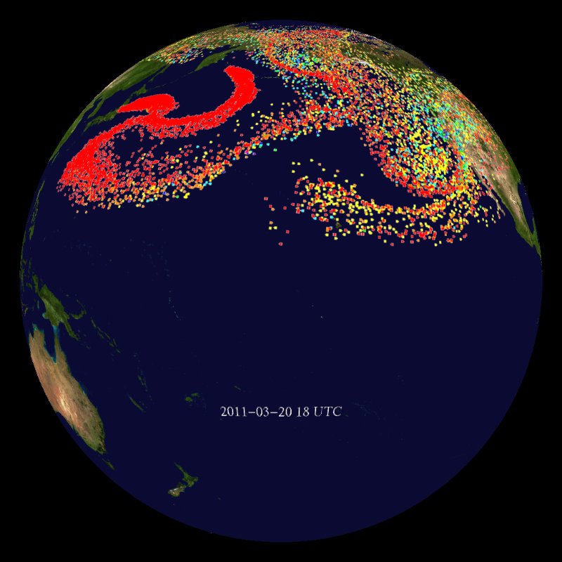
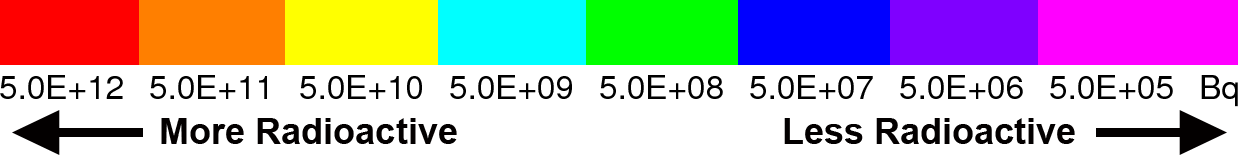
Fukushima Radioactive Aerosol Dispersal
March 13, 2013, 20:09
Filed under: maps | Tags: bone cancer, cesium, Cesium-137, contamination, Fukushima, HYSPLIT, hysplit model, Iodine-131, meltdown, multiple meltdown, NOAA, radiation, radioactive cesium, thyroid cancer
Filed under: maps | Tags: bone cancer, cesium, Cesium-137, contamination, Fukushima, HYSPLIT, hysplit model, Iodine-131, meltdown, multiple meltdown, NOAA, radiation, radioactive cesium, thyroid cancer
NOAA’s HYSPLIT model shows clouds of highly radioactive Cesium wafting over the US after Fuku blew sky high. Only one month’s worth shown.
To see animation:
http://www.sos.noaa.gov/Datasets/dataset.php?id=332
Leave a comment
GOES Magnetometer
July 14, 2012, 18:52
Filed under: Uncategorized | Tags: cosmic rays, electromagnetic, energy, GOES, magnetometer, NOAA, solar flares, solar storm
Filed under: Uncategorized | Tags: cosmic rays, electromagnetic, energy, GOES, magnetometer, NOAA, solar flares, solar storm
via http://www.solarham.net/magnetogram.htm

Another Smoke Map
June 12, 2012, 17:09
Filed under: maps | Tags: denver, forest fire, Fort Collins, High Park Fire, Larimer County, NOAA, smoke map, smoke plume, wildfire, wildland fire
Filed under: maps | Tags: denver, forest fire, Fort Collins, High Park Fire, Larimer County, NOAA, smoke map, smoke plume, wildfire, wildland fire
High Park Fire filled Denver with smoke this morning, but the plume has since pulled back.


Via NOAA: http://www.firedetect.noaa.gov/viewer.htm
